名稱
ST_ClusterKMeans — 使用 K-means 演算法為每個輸入幾何圖形返回群集 ID 的視窗函數。
概要
integer ST_ClusterKMeans(geometry winset geom, integer number_of_clusters, float max_radius);
描述
為每個輸入幾何圖形返回 K-means 群集編號。用於群集的距離是 2D 幾何圖形質心之間的距離,以及 3D 幾何圖形邊界框中心之間的距離。對於 POINT 輸入,M 坐標將被視為輸入的權重,並且必須大於 0。
如果設定了 max_radius,ST_ClusterKMeans 將產生比 k 更多的群集,以確保輸出中沒有群集的半徑大於 max_radius。這在可達性分析中很有用。
增強功能:3.2.0 支援 max_radius
增強功能:3.1.0 支援 3D 幾何圖形和權重
可用性:2.3.0
範例
產生範例用的虛擬地塊集合
CREATE TABLE parcels AS
SELECT lpad((row_number() over())::text,3,'0') As parcel_id, geom,
('{residential, commercial}'::text[])[1 + mod(row_number()OVER(),2)] As type
FROM
    ST_Subdivide(ST_Buffer('SRID=3857;LINESTRING(40 100, 98 100, 100 150, 60 90)'::geometry,
    40, 'endcap=square'),12) As geom;
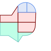
依群集編號 (cid) 著色的地塊
SELECT ST_ClusterKMeans(geom, 3) OVER() AS cid, parcel_id, geom
    FROM parcels;
 cid | parcel_id |   geom
-----+-----------+---------------
   0 | 001       | 0103000000...
   0 | 002       | 0103000000...
   1 | 003       | 0103000000...
   0 | 004       | 0103000000...
   1 | 005       | 0103000000...
   2 | 006       | 0103000000...
   2 | 007       | 0103000000...
依類型分割地塊群集
SELECT ST_ClusterKMeans(geom, 3) over (PARTITION BY type) AS cid, parcel_id, type
    FROM parcels;
 cid | parcel_id |    type
-----+-----------+-------------
   1 | 005       | commercial
   1 | 003       | commercial
   2 | 007       | commercial
   0 | 001       | commercial
   1 | 004       | residential
   0 | 002       | residential
   2 | 006       | residential
範例:使用 3D 群集和權重對預先彙總的行星規模資料人口資料集進行群集。根據 Kontur 人口資料,識別至少 20 個中心距離不超過 3000 公里的區域
create table kontur_population_3000km_clusters as
select
    geom,
    ST_ClusterKMeans(
        ST_Force4D(
            ST_Transform(ST_Force3D(geom), 4978), -- cluster in 3D XYZ CRS
            mvalue => population -- set clustering to be weighed by population
        ),
        20,                      -- aim to generate at least 20 clusters
        max_radius => 3000000    -- but generate more to make each under 3000 km radius
    ) over () as cid
from
    kontur_population;
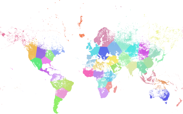
按上述規格群集的世界人口產生 46 個群集。群集集中在人口稠密的地區(紐約、莫斯科)。格陵蘭是一個群集。有些島嶼群集跨越反子午線。群集邊緣遵循地球的曲率。