名稱
ST_灰階 — 從來源網格和指定的紅、綠、藍波段建立一個新的單波段 8BUI 網格
概要
(1) raster ST_灰階(raster rast, integer redband=1, integer greenband=2, integer blueband=3, text extenttype=INTERSECTION);
(2) raster ST_灰階(rastbandarg[] rastbandargset, text extenttype=INTERSECTION);
描述
使用三個輸入波段(來自一個或多個網格)建立一個單波段 8BUI 網格。任何像素類型不是 8BUI 的輸入波段都將使用 ST_Reclass 重新分類。
![[Note]](../images/note.png)
|
|
|
此函數與帶有 |
可用性:2.5.0
範例:變體 1
SET postgis.gdal_enabled_drivers = 'ENABLE_ALL';
SET postgis.enable_outdb_rasters = True;

WITH apple AS (
    SELECT ST_AddBand(
        ST_MakeEmptyRaster(350, 246, 0, 0, 1, -1, 0, 0, 0),
        '/tmp/apple.png'::text,
        NULL::int[]
    ) AS rast
)
SELECT
    ST_AsPNG(rast) AS original_png,
    ST_AsPNG(ST_Grayscale(rast)) AS grayscale_png
FROM apple;
|
 原始_png
|
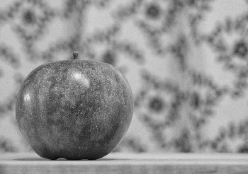 灰階_png
|
範例:變體 2
SET postgis.gdal_enabled_drivers = 'ENABLE_ALL';
SET postgis.enable_outdb_rasters = True;

WITH apple AS (
    SELECT ST_AddBand(
        ST_MakeEmptyRaster(350, 246, 0, 0, 1, -1, 0, 0, 0),
        '/tmp/apple.png'::text,
        NULL::int[]
    ) AS rast
)
SELECT
    ST_AsPNG(rast) AS original_png,
    ST_AsPNG(ST_Grayscale(
        ARRAY[
            ROW(rast, 1)::rastbandarg, -- red
            ROW(rast, 2)::rastbandarg, -- green
            ROW(rast, 3)::rastbandarg, -- blue
        ]::rastbandarg[]
    )) AS grayscale_png
FROM apple;